There is No Place Like Home: The Photographs of Matthew Kaplan


The warm yellow light in the doorway carves out a welcoming spot against the oncoming blue of dusk. The door frame sets a human scale. Nearby, behind in the dark is another single-family house. This is a neighborhood. And beyond both of these homes, where the families that live in them are likely to have known each other for generations, there is a flare stack from the refinery, converting unusable gas into vapor and carbon dioxide, a reminder of the volatility only blocks away. This photograph, shot in Whiting, Indiana by Matthew Kaplan, combines the feeling of home and comfort of a tight-knit neighborhood with the visible signs of corporate power and the hydrocarbon economy. In this juxtaposition, it tells a number of intertwined, contradictory stories: one of America’s production of raw materials into wealth, one of the proud but declining communities economically dependent on the refinery for their well-being, and one of the increasing power of multinational corporations.
Born and raised in Whiting, as was his father, Kaplan is a freelance photographer who has been documenting his hometown, and the surrounding Calumet Region, since the late 1970s. When Kaplan was born in the 1950s, the entire southern shore of Lake Michigan was a booming agglomeration of steel mills, petroleum refineries, and hundreds of other industrial facilities. Describing his childhood, he notes, “The night sky was orange tinted and punctuated with flashes of industrial lighting. Our bedtime soundscape included a low rumble from the nearby steel mills, insistent valve hisses from the American Maize plant a half mile away, and the constant banging of rail cars as they moved in and out of the adjacent freight yards.” Kaplan’s mother still lives in Whiting, in the house where he grew up. Kaplan knows this place intimately. It is home. He has wandered its streets and alleys, attended town events, spent countless hours waiting for the light to enhance his images of the Calumet Region. His photographs place value on his community. In one photograph, the stereotypical white picket fence of the American Dream, turned blue by the evening sky, fills the bottom quarter of the frame. In this photograph, the houses are lit by a nearby evening baseball game. Behind the fence, the yard, and the houses, the forms of the refinery glimmer. Reminders of the gasoline, the heating oil, and the vinyl siding that make this community and others like it across the country possible, they also speak to the threat of explosion, chemical contamination, and the ongoing atmospheric rise in carbon dioxide. And they dominate the view as BP dominates the town.
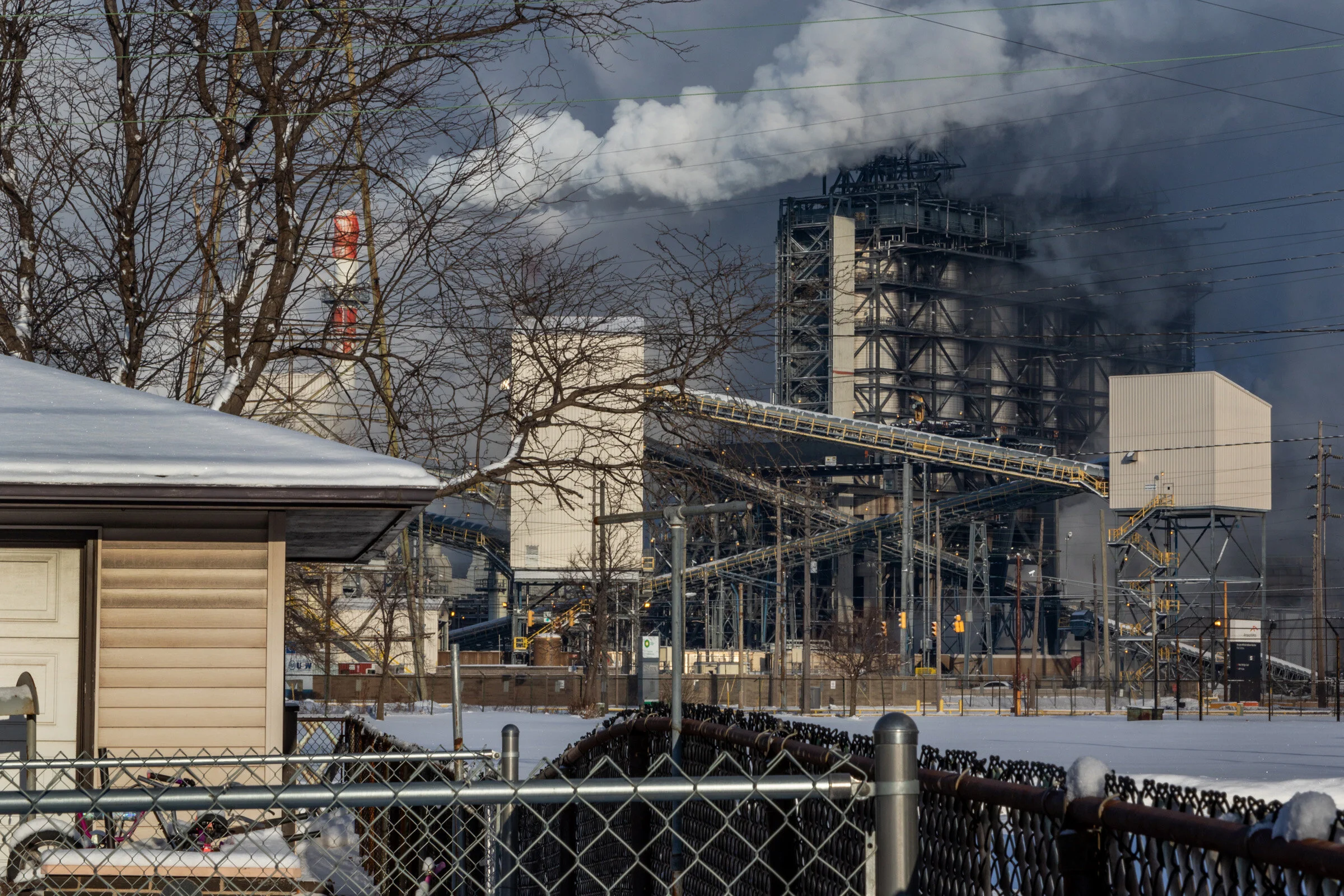
While much of the industrial production of the Calumet region, the heart of the rustbelt, has moved overseas, the BP Whiting Refinery, first owned and operated by John D. Rockefeller’s Standard Oil, is booming. The communities around the refinery—Whiting, Robertsdale, East Chicago—and the plant grew up together. Standard Oil bought land along the Indiana shore of Lake Michigan to build an oil refinery in 1889. At the time, Standard Oil refined and transported at least three-quarters of the crude oil in the United States, using its monopoly power to extract special deals from the railroads. In 1911, after the U.S. Supreme Court upheld a decision to break up Standard Oil under anti-trust laws, Standard Oil of Indiana became the owner of Whiting’s refinery. It was here that William Burton, Manager of Manufacturing, and Robert Humphrey, Chief Chemist, lead research to “crack” hydrocarbons into the smaller molecules necessary for gasoline. Their success doubled the amount of gasoline that could be extracted from crude oil, allowing refiners to supply the surging demand that accompanied the growth of private car ownership. And as the refinery grew, employing 4,000 people by 1923, so did the towns. Whiting built schools, a library, parks, and a central shopping street with a nearby community center donated by the oil company and the Rockefeller family. While once intertwined, the fortunes of the towns and the refinery are now on separate trajectories. BP’s profits have doubled in the last two years, with the Whiting plant delivering record throughput. Changing methods of production, though, mean Whiting itself, by contrast, has less than one half of its peak population and the average median income has fallen to below that of the United States as a whole.
“While once intertwined, the fortunes of the towns and the refinery are now on separate trajectories.”
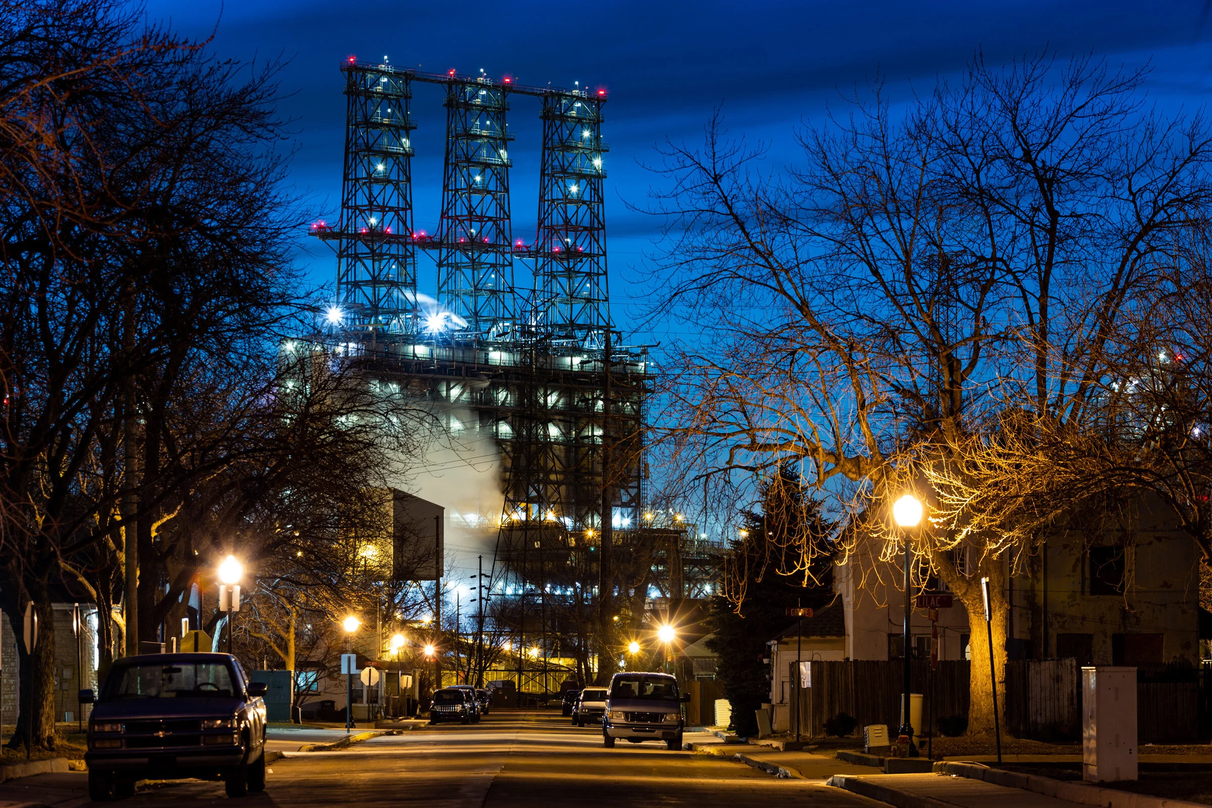
On the other side of the refinery is the crumbling Marktown district of East Chicago, Indiana. A planned community for steel workers built by Mark Manufacturing in 1917, Marktown was designed in a vaguely English Tudor Revival style by Howard Van Doren Shaw, better known for his tony suburban communities like Lake Forest on Chicago’s North Shore. Only a fraction of the original plan was completed, after the outbreak of the First World War interrupted construction, and in later years Marktown was surrounded by U.S. Steel, ArcelorMittel, and the growing Whiting Refinery. Marktown looks like no other place. Kaplan has captured its unique architecture. In one photo with a picnic table in the foreground, interlocking geometric shapes of the buildings painted pink and ochre, the sharp angles of the roofs, the rectangle made by the windowed entryway and the forms of tree shadows contrast with the gentle, curvy wave of the top line of the fence that separates one yard from another. Even here though, a refinery smoke stack intrudes. In Kaplan’s evening photo of the refinery’s new coker, it looms over Marktown, its industrial scale dwarfing the houses and cars, a scale never imagined when Marktown was built. This 2013 upgrade to the plant allows it to process Canadian oil sands, which are much dirtier than other petroleum deposits. It adds one billion dollars a year to the plant’s cash flow. Meanwhile, Marktown is losing its fight for survival. BP has offered to buy out homeowners wishing to sell. But it pays only $20,000 to $30,0000, not enough to relocate. In Kaplan’s photo of one of the original two-family houses, one side is occupied and one side is abandoned. The evening light brings out the unusual shape of the building itself, with its double peaked roof. The windows are the key: one set boarded up, one with curtains in the living room window. They state the different fortunes of the families who live here: those who can’t afford to stay and those who can’t afford to leave.
Kaplan, in his long-term documentation of Whiting and the Calumet Region has captured the struggle between community and commerce as it has played out over decades. Home and industry, opposites, exist in the same frame in Kaplan’s photographs. The homes near the refinery, both the clapboard houses of Whiting and the stucco duplexes of Marktown, represent the lives of the people living, raising families, and growing old there. These are people Kaplan grew up with and still knows. Kaplan expresses his love for this place by making it beautiful with strong, formal compositions and lovely light and color. And each photograph with its local story tells part of the larger saga of the constant change of the American economy, the exploitation of raw materials, the power of technology, the concentration of wealth, the automation and mechanization of the workplace. Each of Kaplan’s photographs reminds us that these forces impact actual people and their very real neighborhoods.
Citation
Robin Michals, “There is No Place Like Home: The Photographs of Matthew Kaplan,” Platform, October 3, 2019.
Notes
Powell A. Moore, The Calumet Region: Indiana’s Last Frontier (Indiana Historical Society, 1959), 213-14.
Daniel Yergin, The Prize: The Epic Quest for Oil, Money, & Power (New York: Simon & Schuster, 1991), 110-12.